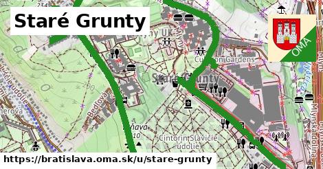
čísla, 1 z 5
3761/322A ¤, 12 ¤, 13 ¤, 130 ¤, 132 ¤, 134 ¤, 134A ¤, 14 ¤, 142 ¤, 148 ¤, 148A ¤, 150 ¤, 152 ¤, 154 ¤, 156 ¤, 158 ¤, 158A ¤, 160 ¤, 162 ¤, 164 ¤, 166 ¤, 168 ¤, 168A ¤, 17 ¤, 170 ¤, 172 ¤, 172A ¤čísla, 2 z 5
174 ¤, 176 ¤, 178 ¤, 17A ¤, 18 ¤, 180 ¤, 182 ¤, 184 ¤, 186 ¤, 188 ¤, 19 ¤, 190 ¤, 192 ¤, 194 ¤, 196 ¤, 198 ¤, 1A ¤, 1B ¤, 1C ¤, 200 ¤, 202 ¤, 204 ¤, 206 ¤, 208 ¤, 21 ¤, 210 ¤, 212 ¤čísla, 3 z 5
214 ¤, 214A ¤, 214B ¤, 214C ¤, 216 ¤, 218 ¤, 21A ¤, 220 ¤, 222 ¤, 224 ¤, 226 ¤, 228 ¤, 23 ¤, 230 ¤, 232 ¤, 234 ¤, 236 ¤, 238 ¤, 24 ¤, 240 ¤, 242 ¤, 242A ¤, 244 ¤, 26 ¤, 260 ¤, 262 ¤, 264 ¤čísla, 4 z 5
26A ¤, 26B ¤, 26C ¤, 26D ¤, 26E ¤, 26F ¤, 26G ¤, 26H ¤, 3 ¤, 324A ¤, 324B ¤, 324C ¤, 324D ¤, 326A ¤, 326B ¤, 328 ¤, 332 ¤, 36 ¤, 38 ¤, 4 ¤, 40 ¤, 47 ¤, 49 ¤, 49A ¤, 5 ¤, 50 ¤, 51 ¤čísla, 5 z 5
51A ¤, 52 ¤, 52A ¤, 53 ¤, 53A ¤, 53B ¤, 53C ¤, 53D ¤, 55 ¤, 56 ¤, 5692 ¤, 6 ¤, 61 ¤, 6280 ¤, 6281 ¤, 6283 ¤, 7 ¤, 7A ¤, 7B ¤, 7C ¤, 8 ¤, 9A ¤, 9B ¤, 9C ¤, 64 ¤Obchod
Terno ¤, Pekáreň Mlyny ¤, Zero ¤, Cent ¤, Cent ¤, Dalno ¤, bolsius ¤, Kvetinárstvo Bosco ¤, Loding ¤, LM ¤, River Woods ¤, dm ¤, Prešporská púpava ¤, Billa ¤, Prigmi ¤, Cent ¤, Tiny toe ¤, CosmoParis ¤, Morgan ¤, Flamant ¤, Martinus ¤, Knip ¤, Cent ¤, Durance ¤, Yamamay ¤, Sušené ovocie ¤, Starý Otec ¤, Eureka kids ¤, Talianka ¤, La Mademoiselle ¤Stravovanie
White Dragon ¤, Pizza&Pasta ¤, index CAFE BAR ¤, Knip ¤, Eat&Meet ¤, DoNčos ¤, Drag ¤, Starý Otec ¤, elia Oliva ¤, Palmyra ¤, Les Fournils de France ¤, Idyla ¤, Bistro Mladosť ¤, Mlynská Koliba ¤, Bufet DELIKANTI ¤, Grill 53 ¤, Jedáleň DELIKANTI ¤, rýchle občerstvenie ¤, Študentka ¤Turistika
Mlynská dolina, internáty ¤, prístrešok, altánok ¤, prístrešok, altánok ¤, prístrešok, altánok ¤, Mlynská dolina ¤, Vyhľadávanie hrobov ¤, ohnisko ¤, turistické informácie ¤, prístrešok, altánok ¤, prístrešok, altánok ¤, prístrešok, altánok ¤šport
detské ihrisko ¤, detské ihrisko ¤, Hamilton ¤, FunCity ¤, Titan gym ¤, multi ¤, True Strength ¤, tenis ¤, ihrisko ¤, basketbal ¤, basketbal ¤, tenis ¤, ihrisko ¤, boules ¤, detské ihrisko ¤, stolný tenis ¤, plážový volejbal ¤, Telocvičňa Mladosť ¤Voľný čas
Niké ¤, Klub 31 ¤, Klub 39 ¤, park ¤, UniK Mlyny ¤, Univerzitné pastoračné centrum svätého Jozefa Freinademetza ¤, Slovenská technická univerzita v Bratislave, Fakulta informatiky a informačných technológií - Slovenská informatická knižnica ¤, park ¤, Archív Univerzity Komenského ¤Služby
kôš ¤, Bonet Systems ¤, MRAMOR CSÖGLEI ¤, Inžiniersko-projektová organizácia školských stavieb, a. s. ¤, In-Life ¤, toaleta ¤, kôš ¤, kôš ¤, Bitcoinmat.sk ¤, bankomat ¤, Aegon ¤, číslo S6AV022X ¤, bankomat ¤, Slovenský zväz včelárov ¤, kôš ¤, kôš ¤, kôš ¤, toaleta ¤, Veľvyslanectvo Izraela ¤, kôš ¤, Anasoft APR, s.r.o. ¤, kôš ¤, bankomat ¤, kôš ¤, kôš ¤, kôš ¤, kôš ¤, kôš ¤, toaleta ¤, toaleta ¤Doprava
Vretenová ¤, Nad vinicami ¤, Na Sitine ¤, Nad vinicami ¤, Rudolfa Mocka ¤, Na Sitine ¤, Panoráma ¤, Panoráma ¤, Bedľová ¤, Bedľová ¤, Tôňava ¤, Vretenová ¤, Cintorín Slávičie ¤, Tôňava ¤, Rudolfa Mocka ¤, Televízia ¤, Cintorín Slávičie ¤, Cintorín Slávičie ¤, automat na lístky ¤, Zoo ¤, Televízia ¤, Zoo ¤, automat na lístky ¤, Zoo ¤, Zoo ¤, Hájnická ¤Auto
parkovisko ¤, parkovisko ¤, parkovisko ¤, parkovisko ¤, parkovisko ¤, parkovisko ¤, parkovisko ¤, parkovisko ¤, parkovisko ¤, parkovisko ¤, parkovisko ¤, parkovisko ¤, parkovisko ¤, parkovisko ¤, parkovisko ¤, ZSE Drive - Staré Grunty ¤, parkovisko ¤, parkovisko ¤, parkovisko ¤, ZSE Drive Cubicon ¤, parkovisko ¤, parkovisko ¤, parkovisko ¤, parkovisko ¤, parkovisko ¤, parkovisko ¤, parkovisko ¤, parkovisko ¤, parkovisko ¤, parkovisko ¤Zdravotníctvo
Mlynská dolina ¤, Poliklinika Mlynská dolina ¤, veterinár ¤, veterinár ¤, Rubicon ¤, Všeobecna ambulancia pre dospelých ¤Duchovno
Univerzitné pastoračné centrum svätého Jozefa Freinademetza ¤, kríž ¤, Cintorín Slávičie údolie ¤Pamiatky
pamätník ¤, socha ¤, Bojovníkom proti fašizmu ¤, socha ¤, socha ¤, socha ¤, socha ¤, socha ¤, socha ¤, socha ¤, socha ¤, socha ¤, pamätník ¤, socha ¤, socha ¤, socha ¤, Reliéf s motívom výuky zrakovo postihnutých detí ¤Bicykel
cyklostojan ¤, WhiteBikes - BINARIUM ¤, cyklostojan ¤, WhiteBikes - ATRIAKY ¤, cyklostojan ¤, cyklostojan ¤Prístupnosť
Bedľová ¤, Bedľová ¤, Bonet Systems ¤, Terno ¤, Poliklinika Mlynská dolina ¤, parkovisko ¤, Z-Box ¤, Eat&Meet ¤, Z-Box ¤, True Strength ¤, parkovisko ¤, Idyla ¤, Mlynská Koliba ¤, toaleta ¤, toaleta ¤, Lidl ¤