Obchod
potraviny ¤, žiaden ¤, Kaufland ¤, Victor ¤, Mediapress ¤, kaderníctvo ¤, Elektroprodukt, s. r. o. ¤, dm ¤, Delikana ¤, Pepco ¤, Dráčik ¤, kik ¤, Super Zoo ¤, Gerbera ¤, Potraviny Freshco ¤, malina ¤, Vinotéka Ambriel ¤, Bajamarket, potraviny Javorina ¤, Voňavý domov ¤, Byt-in ¤, Večierka u Leily ¤, kaderníctvo ¤, Baracuda lahôdky ¤, potraviny ¤, potraviny ¤Stravovanie
Moony's ¤, Slovnaft - závodná jedáleň ¤, Panda ¤, Maranello ristorante ¤, Minute fresh food bar ¤, Delikana ¤, pohostinstvo ¤, Saigon bistro ¤, Fresh Corner ¤, Espresso Jakša ¤, Motorest Racing ¤šport
Detské ihrisko „Inovec“ ¤, tenis ¤, plaváreň ¤, Plaváreň Slovnaft ¤, tenis ¤, tenis ¤, detské ihrisko ¤, detské ihrisko ¤, tenis ¤, Slovnaft RELAX ¤Voľný čas
park ¤, park ¤, park ¤, park ¤, park ¤, park ¤, park ¤, park ¤, park ¤, park ¤, park ¤, miesto na uviazanie psov ¤, park ¤, park ¤, miesto na uviazanie psov ¤, park ¤, park ¤, miesto na uviazanie psov ¤, Baracuda disco bar ¤Služby
kôš ¤, kôš ¤, bankomat ¤, kôš ¤, kôš ¤, kôš ¤, kôš ¤, kôš ¤, kôš ¤, toaleta ¤, Slovenská sporiteľňa ¤, kôš ¤, číslo S6AV062Z ¤, POWER BELT pohonné mechanizmy s.r.o. ¤, Dom obchodných činností ¤, číslo S6AV062P ¤, číslo 0113 ¤, číslo S6AV062B ¤, kôš ¤, Virtual Point Bratislava ¤, ARCH GALLERY ¤Doprava
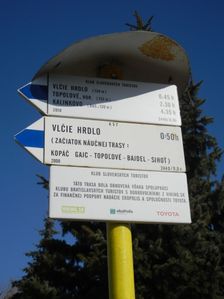
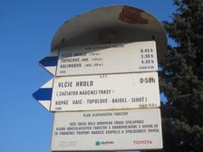
Čierny les ¤, Čierny les ¤, Piesčiny ¤, Piesčiny ¤, Závodná ¤, V. hrdlo, internát ¤, Lúčna ¤, OC Slovnaftská ¤, V. hrdlo, internát ¤, Závodná ¤, OC Slovnaftská ¤, Pálenisko ¤, Pálenisko ¤, Vlčie hrdlo ¤, Vlčie hrdlo ¤, automat na lístky ¤, Vlčie hrdlo ¤, Vlčie hrdlo ¤, automat na lístky ¤, Vlčie hrdlo ¤, Alejová ¤, Slovnaftská ¤, Alejová ¤Auto
parkovisko ¤, parkovisko ¤, číslo P3 ¤, Slovnaft ¤, autoumyváreň ¤, parkovisko ¤, parkovisko ¤, parkovisko ¤, číslo P2 ¤, parkovisko ¤, číslo P2 ¤, parkovisko ¤, parkovisko ¤, parkovisko ¤, parkovisko ¤, parkovisko ¤, parkovisko ¤, číslo P2 ¤, parkovisko ¤, parkovisko ¤, parkovisko ¤, parkovisko ¤, parkovisko ¤, Autoservice Osvald ¤, parkovisko ¤, parkovisko ¤, parkovisko ¤, parkovisko ¤, parkovisko ¤, Penový raj ¤Bicykel
cyklostojan ¤, Slovnaft ¤, miesto na uviazanie psov ¤, miesto na uviazanie psov ¤, Slovnaft hlavný vchod ¤, cyklostojan ¤, cyklostojan ¤, miesto na uviazanie psov ¤, cyklostojan ¤, cyklostojan ¤, cyklostojan ¤, Slovnaft ¤Prístupnosť
Kaufland ¤, lekáreň ¤, Mediapress ¤, toaleta ¤, dm ¤, Pepco ¤, Dráčik ¤, okay ¤, Super Zoo ¤