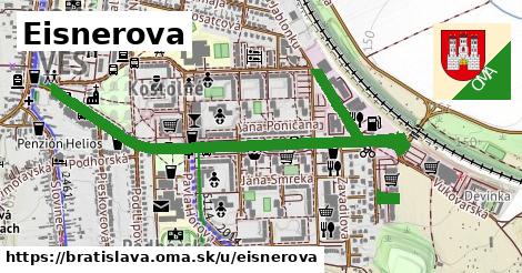
čísla, 1 z 2
17 ¤, 19 ¤, 2 ¤, 21 ¤, 26 ¤, 27 ¤, 29 ¤, 3 ¤, 38 ¤, 4 ¤, 40 ¤, 42 ¤, 44 ¤, 48 ¤, 5 ¤, 52 ¤, 52A ¤, 52B ¤, 52C ¤, 56A ¤, 56B ¤, 56C ¤čísla, 2 z 2
56E ¤, 56F ¤, 56G ¤, 56H ¤, 58A ¤, 58B ¤, 6 ¤, 60 ¤, 7 ¤, 11 ¤, 13 ¤, 15 ¤, 25 ¤, 35 ¤, 46 ¤, 50 ¤, 54 ¤, 6327/56C ¤, 9 ¤, 64 ¤, 6510 ¤Obchod
predaj lístkov ¤, predaj lístkov ¤, Miran ¤, Emona ¤, Shar ¤, Terno ¤, kaderníctvo ¤, Lidl ¤, KRAJ ¤, Negrezza ¤, dm ¤, Tesco ¤, Vinotéka Don Luca ¤, Nákupné centrum Glavica ¤, Delia ¤Stravovanie
Sultan Kebab ¤, Emona ¤, Shar ¤, pohostinstvo ¤, Šport pub Pumpa ¤, Breweria ¤, Tom's Burger ¤, Tom's Burger ¤, Colorado ¤, Formula ¤, Cafe Esso u Baču ¤, U Michala ¤, Corleone ¤, Oscar ¤, socha ¤, Piváreň u Jumba ¤, Pizzeria Corleone ¤, Reštaurácia u Bronďáka ¤šport
detské ihrisko ¤, detské ihrisko ¤, Plavecká akadémia ¤, Bowl ¤, Bowl ¤, detské ihrisko ¤, ihrisko ¤, detské ihrisko ¤, detské ihrisko ¤Voľný čas
miesto na uviazanie psov ¤, Istra Centrum - CVČ ¤, F Centrum ¤, Miestna knižnica Devínska Nová Ves ¤Služby
bankomat ¤, číslo S6AV012P ¤, bankomat ¤, Všeobecná úverová banka ¤, bankomat ¤, bankomat ¤, číslo S6AV022C ¤, číslo S6AV012C ¤, Bratislava 49 ¤, Obvodné oddelenie PZ Devínska Nová Ves ¤Doprava
predaj lístkov ¤, automat na lístky ¤, Štefana Králika ¤, Hradištná ¤, Milana Marečka ¤, Štefana Králika ¤, Hradištná ¤, Milana Marečka ¤, predaj lístkov ¤, Uhrovecká ¤, Ivana Bukovčana ¤, Ivana Bukovčana ¤, Uhrovecká ¤Auto
parkovisko ¤, parkovisko ¤, parkovisko ¤, parkovisko ¤, parkovisko ¤, parkovisko ¤, parkovisko ¤, Slovnaft ¤, parkovisko ¤, parkovisko ¤, parkovisko ¤, parkovisko ¤, parkovisko ¤, parkovisko ¤, parkovisko ¤, parkovisko ¤, parkovisko ¤, parkovisko ¤, parkovisko ¤, parkovisko ¤, parkovisko ¤, parkovisko ¤, parkovisko ¤Zdravotníctvo
ordinácia ¤, Lekáreň Nada ¤, Centrum imunológie a alergológie ¤, Zdravotné stredisko Devínska Nová Ves ¤, Lekáreň Liberi ¤, MUDr. Kohnová ¤Duchovno
Kaplnka s Pietou ¤, Kostol Ducha Svätého ¤, kríž ¤, Sála kráľovstva Jehovových svedkov ¤, Cintorín Devínska Nová Ves ¤, Panna Mária s dieťaťom ¤Vzdelanie
skôlka ¤, Materská škola Pavla Horova 3 ¤, skôlka ¤, Materská škola Milana Marečka ¤, skôlka ¤Pamiatky
Nenarodeným deťom ¤, Pieta ¤, Matica slovenská ¤, sv. Ján Nepomucký ¤, socha ¤, pamätník ¤, sv. Júda Tadeáš ¤, Panna Mária s dieťaťom ¤, socha ¤, fontána ¤, Dvojica ¤, Pomník Rudolfa Slobodu ¤