Obchod
ahrend ¤, 101 Drogerie ¤, Anker ¤, MiHi.sk, s.r.o. ¤, Media Press ¤, Salón Medea Styl ¤, gardenium ¤, Crocus ¤, Compex Data ¤, Terno ¤Stravovanie
Viet Hoang ¤, Quan Ngon ¤, Greek Style ¤, Thali ¤, Sushi Time ¤, verejný gril ¤, Bigger Snack World ¤, Jedáleň ministerstva ¤, verejný gril ¤, Veg life ¤, pitná voda ¤, Partizánska lúka (Martinov prameň) ¤, City Cantina Square ¤, City Cantina Westend Gate ¤, La Donuteria ¤, rýchle občerstvenie ¤, Žufet ¤, Powerlogy space&coffee ¤, Anatolia ¤, D&S ¤, Fresh Garden Salads ¤, Kaviareň Crocus ¤, Bemi Restaurant ¤Turistika
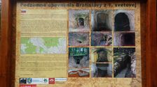
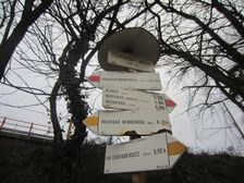
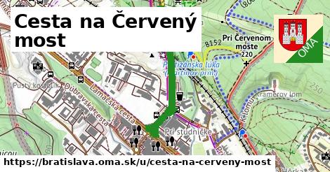
Partizánska lúka ¤, Červený most ¤, Mestské lesy v Bratislave ¤, Podzemné opevnenia Bratislavy z 1. svetovej ¤, prístrešok, altánok ¤, prístrešok, altánok ¤, Partizánska lúka ¤, 85 mm protilietadlový kanón vz. 44 vyrobený v roku 1953 ¤, Altánok pri dele ¤, prístrešok, altánok ¤, prístrešok, altánok ¤, ohnisko ¤, prístrešok, altánok ¤, Les nie je smetisko ¤, Bratislavské Mestské lesy ¤, Panel 5 - Ihličnaté dreviny ¤, Červený most ¤, Voľnočasový areál Partizánska lúka ¤, Certifikácia lesov FSC ¤, Panel 1 - Stromy - živí svedkovia času ¤, Panel 2 - Drevo v službách človeka ¤, Podhorská besiedka ¤, turistické informácie ¤, Panel 4 - Listnaté dreviny 2 ¤, Drevený xylofón ¤, Panel 3 - Listnaté dreviny 1 ¤šport
ihrisko ¤, Detské ihrisko pre veľké deti ¤, detské ihrisko ¤, boules ¤, boules ¤, ihrisko ¤, stolný tenis ¤, stolný tenis ¤, Detské ihrisko pre malé deti ¤Služby
kôš ¤, kôš ¤, Pamiatkový úrad Slovenskej republiky ¤, Ministerstvo dopravy ¤, Westend Plazza ¤, Štatistický úrad Slovenskej republiky ¤, Národná diaľničná spoločnosť ¤, Westend Gate ¤, bankomat ¤, Westend Plazza ¤, kôš ¤, kôš ¤, Westend Gate ¤, IBM International Services Centre s. r. o. ¤, kôš ¤, Tlačová agentúra Slovenskej republiky ¤, toaleta ¤, EXCLUSIVE Garden ¤, Westend Square ¤, Ústav pre výskum srdca SAV ¤, Generali Slovensko ¤, Elokované pracovisko MIRRI SR ¤, Westend Court ¤, bankomat ¤, Geofyzikálny ústav SAV ¤, Siemens s.r.o. ¤, Siemens Healthcare s.r.o. ¤, Bratislava 45 ¤, Ústav stavebníctva a architektúry SAV ¤, notár ¤Doprava
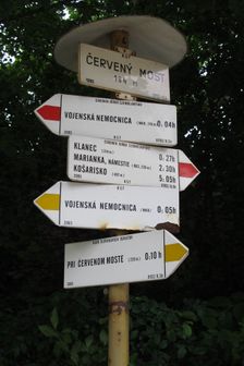
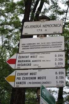
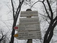
Partizánska lúka ¤, Partizánska lúka ¤, Červený most ¤, Červený most ¤, Červený most ¤, automat na lístky ¤, Červený most ¤, Bratislava-Železná studienka ¤Auto
ZSE Železná studnička ¤, ZSE Železná studnička ¤, ZSE Železná studnička ¤, ZSE Železná studnička ¤, Partizánska lúka ¤, Partizánska lúka ¤, ZSE Železná studnička ¤, parkovisko ¤, parkovisko ¤, parkovisko ¤, parkovisko ¤, umývarňa bicyklov ¤, parkovisko ¤, parkovisko ¤, parkovisko ¤, Westend Plazza ¤, parkovisko ¤, Westend Plazza ¤Prístupnosť
ZSE Železná studnička ¤, ZSE Železná studnička ¤, ZSE Železná studnička ¤, ZSE Železná studnička ¤, ZSE Železná studnička ¤, Bratislava-Železná studienka ¤, pitná voda ¤, Powerlogy space&coffee ¤, Generali Slovensko ¤, Compex Data ¤, Bemi Restaurant ¤, Terno ¤