čísla, 1 z 3
10B ¤, 10D ¤, 11 ¤, 12 ¤, 12A ¤, 13 ¤, 14 ¤, 15 ¤, 16 ¤, 18 ¤, 2 ¤, 22 ¤, 22A ¤, 23 ¤, 2A ¤, 2B ¤, 2D ¤, 3 ¤, 30A ¤, 30B ¤, 30D ¤, 30E ¤, 30F ¤, 32A ¤, 32B ¤, 32C ¤, 32D ¤, 32E ¤čísla, 2 z 3
32F ¤, 32G ¤, 32H ¤, 32K ¤, 33 ¤, 34 ¤, 36 ¤, 36A ¤, 37 ¤, 39 ¤, 4 ¤, 43 ¤, 45 ¤, 49 ¤, 51 ¤, 53 ¤, 55 ¤, 57 ¤, 59 ¤, 6 ¤, 61 ¤, 63 ¤, 65 ¤, 65A ¤, 65B ¤, 67 ¤, 67A ¤, 69 ¤čísla, 3 z 3
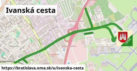
7 ¤, 71 ¤, 73 ¤, 79 ¤, 81 ¤, 83 ¤, 85 ¤, 87 ¤, 89 ¤, 91 ¤, 93 ¤, 10 ¤, 10143 ¤, 10C ¤, 15A ¤, 19 ¤, Ivanska cesta 2 ¤, 21 ¤, 21A ¤, 24A ¤, 25 ¤, 26 ¤, 27 ¤, 28 ¤, 2C ¤, 32 ¤, 8 ¤, 8A ¤Obchod
Jutex Slovakia, s. r. o. ¤, žiaden ¤, Sportisimo.sk ¤, Śnieżka ¤, Chateau Krakovany - podniková predajňa ¤, TABAK PRESS ¤, Kaderníctvo ¤, žiaden ¤, Diego ¤, Pánske obleky BANDI ¤, ZIK ¤, Samok - thajské masáže ¤, Zdravo chutne ¤, Kärcher ¤, Outdoor Guide ¤, žiaden ¤, Phase sedačky ¤, Design House ¤, žiaden ¤, Panta Rhei ¤, Peek & Cloppenburg ¤, darčeková predajňa ¤, KOLO ¤, žiaden ¤, DELIA ¤, ellebi design studio ¤, La Bella Beauty Saloon ¤, kaderníctvo ¤, Tabak Press ¤, Gant ¤Ubytovanie
Penzión Slovport ¤, Aviator Garni Bratislava ¤, Avion ¤, Prima ¤, Školský internát ¤, Gate One ¤, Prima ¤, Hotel Star ¤Stravovanie
Gurman ¤, JETBAR ¤, Saigon bistro ¤, Marco ¤, Mastercard Caproni Lounge ¤, rýchle občerstvenie ¤, eat & fly! ¤, Študentská kantína ¤, Svoi ¤, eat & fly! ¤, Volare ¤, Coffee shop company ¤, Prima Pub ¤, Švédske bistro ¤, McDonald's ¤, KOFI ¤, U Škóta ¤, Vert ¤, Švédska reštaurácia ¤, Švédska kaviareň ¤, Gourmet ¤, Pati ¤Turistika
Fafruny ¤, Letisko M. R. Štefánika ¤, Sochárske diela ¤, Letisko M.R. Štefánika ¤, prístrešok, altánok ¤, Za cestou ¤šport
Jump Arena ¤, Big Hug Gym ¤, Aircraft Sport House ¤, Kids House ¤, ihrisko ¤, detské ihrisko ¤, park pre psov ¤, detské ihrisko ¤, detské ihrisko ¤, detské ihrisko ¤, Šport centrum ¤, detské ihrisko ¤, detské ihrisko ¤Voľný čas
miesto na uviazanie psov ¤, park ¤, Európske Centrum Výtvarných Umení Bratislava ¤, miesto na uviazanie psov ¤, Art Gallery SCULPIO ¤, miesto na uviazanie psov ¤, park ¤, Royal Admiral ¤, park ¤, park ¤, park ¤, park ¤, miesto na uviazanie psov ¤, park ¤, park ¤Služby
BigMedia ¤, kôš ¤, číslo S2CS302K ¤, Alarmy ¤, OLO ¤, toaleta ¤, Business centrum AIRCRAFT ¤, číslo S6AN0151 ¤, Kvakomat Bitcoin ATM ¤, bankomat ¤, číslo S6AV062G ¤, toaleta ¤, toaleta ¤, kôš ¤, kôš ¤, Štátny geologický ústav Dionýza Štúra ¤, SWISS ¤, SWISS s.r.o - Servis ¤, incon ¤, Bitcoin ATM Aupark Kvakomat ¤, kôš ¤, kôš ¤, kôš ¤, kôš ¤, kôš ¤, kôš ¤, Goddess property ¤, kôš ¤, toaleta ¤, toaleta ¤Doprava
Fafruny ¤, Fafruny ¤, Avion Shop. Park ¤, Ivanská cesta ¤, Letisko (Airport) ¤, Letisko (Airport) ¤, Slowackého ¤, Letisko (Airport) ¤, Avion, IKEA ¤, číslo 544 ¤, Letisko (Airport) ¤, Avion, IKEA ¤, číslo 543 ¤, číslo 542 ¤, Pri letisku ¤, Pri letisku ¤, Slowackého ¤, číslo 471 ¤, Avion Shop. Park ¤, Planét ¤, Planét ¤, Ivanská cesta ¤, Avion Shop. Park ¤, číslo 554 ¤, číslo 553 ¤, taxi ¤, Letové služby ¤Auto
parkovisko ¤, P1 ¤, parkovisko ¤, nabíjacia stanica ¤, parkovisko ¤, parkovisko ¤, parkovisko ¤, parkovisko ¤, parkovisko ¤, parkovisko ¤, parkovisko ¤, parkovisko ¤, parkovisko ¤, parkovisko ¤, parkovisko ¤, parkovisko ¤, M2 parking ¤, parkovisko ¤, parkovisko ¤, parkovisko ¤, 24h Oil ¤, parkovisko ¤, Inter Cars ¤, parkovisko ¤, parkovisko ¤, parkovisko ¤, parkovisko ¤, GAT ¤, Indian motorcycle of Bratislava ¤, červené 4B ¤Zdravotníctvo
Unizdrav ¤, defiblirátor ¤, Íris ¤, defiblirátor ¤, defiblirátor ¤, Dr. Max ¤, Prvá klinika akupunktúry a naturálnej medicíny G. Solára ¤, zhromaždisko ¤, zhromaždisko ¤, Super zoo veterina ¤Vzdelanie
Škôlka Vilka ¤, Materská škola Piesočná 2 ¤, Stredná odborná škola technológií a remesiel ¤, Detské opatrovateľské centrum Tulipánik ¤Pamiatky
Oslobodenie Bratislavy ¤, Základný kameň odbavovacej budovy ¤, Štefan Banič ¤, fontána ¤, socha ¤, socha ¤, fontána ¤Bicykel
miesto na uviazanie psov ¤, cyklostojan ¤, cyklostojan ¤, 24h Oil ¤, miesto na uviazanie psov ¤, miesto na uviazanie psov ¤, IKEA ¤, IKEA ¤, cyklopumpa ¤, Avion Shopping Park ¤, Avion ¤, OMV ¤, cyklostojan ¤, miesto na uviazanie psov ¤, DXC Technology ¤Prístupnosť
Letisko (Airport) ¤, Letisko (Airport) ¤, Letisko (Airport) ¤, Letisko (Airport) ¤, P1 ¤, TABAK PRESS ¤, Kaderníctvo ¤, Pánske obleky BANDI ¤, ZIK ¤, Zdravo chutne ¤, parkovisko ¤, rýchle občerstvenie ¤, toaleta ¤, číslo S6AN0151 ¤, bankomat ¤, číslo S6AV062G ¤, Panta Rhei ¤, darčeková predajňa ¤, eat & fly! ¤, Volare ¤, toaleta ¤, Tabak Press ¤, Coffee shop company ¤, C&A ¤, Dr. Max ¤, Školský internát ¤, P2 ¤, Švédske bistro ¤, Sendy ¤, McDonald's ¤